Fieldwork at Low Bewley: Project Report
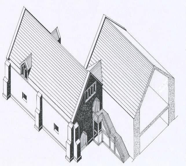 Conjectural reconstruction of the prior’s chapel at Bewley, from the north-west, showing its link to the part-excavated camera or hall, and its external west doorways (© Martin Roberts)
In the medieval period the Benedictine monks of Durham Priory held large amounts of land in the north-east of England. The produce and revenue from these lands paid for the monks at Durham. In order to manage the lands Durham Priory established Administrative Centres near their major landholdings and these centres sometimes developed into Great Houses with a complex of buildings and farms. The main buildings might be quite lavish and would have been used as a retreat by the Prior and noble guests. Durham Priory was given land at Billingham shortly after the Norman Conquest and it had a farming centre at Bewley by 1244 at the latest. It is recorded that Prior Hugh de Darlington built a Manor House here between 1258 and 1273.
As part of the Durham University ‘Belief in the North East’ Heritage Lottery Funded project we carried out fieldwork with Tees Archaeology at Daffodil Park, Billingham to try to identify remains of this medieval settlement. The site was the location of a farmstead which was demolished in the early 1960s as part of the construction of a housing estate in the surrounding area. At the time of its demolition the identification of the site with that of the Prior of Durham’s medieval manor house at Bewley was suggested by Leslie Still and limited building recording and archaeological excavation in 1960 and 1961 confirmed this.
This is what we found (you can download a full version of the report at the bottom of this page)
The Buildings
Three buildings of probable medieval date were encountered, one in trench 1 and two in trench 2.
Earliest Building
A small part of this was encountered in trench 2. This may have been related to an earlier structure excavated by Still which pre-dated that seen in Trench 1 and according to Still its walls underlie the building excavated in this trench. On this evidence it would have been one of the earliest parts of the manorial complex. It is probably best seen not as a single free-standing structure but as part of a complex housing multiple spaces with different uses as seen in monastic complexes. The date of the building represented by this feature is uncertain but it is probably 13th century.
Trench 1 Building
This structure had very substantial walls and was clearly an important building in the manorial complex. Still had investigated the exterior walls of the building in Trench 1 and provides images in his report which clearly demonstrate a substantial structure with some architectural detailing. This building is discussed above in detail by Martin Roberts and it clearly comprised a chapel and Undercroft complex.
Trench 2 Building
The structure defined by walls 203 and 209 was described by Still as a cow shed., whatever its latest function the archaeological evidence points to a more domestic use earlier in its life. We do not however know when it was built, the changes to its walls suggests that it had quite a long life, but it was clearly later than the structure represented by 210 and the pieces of medieval masonry built into its walls may have come from the underlying structure.
While it was not the first medieval building in this location the high status feasting suggested by some of the animal bones may indicate that it was a structure of some importance and would be consistent with a late medieval date.
In this context it should be noted that the buildings at Low Grange were leased by the Prior in 1409 and this was preceded by a period of extensive repair. It is possible that the demolition of the earliest building and the construction of this one dates from that period. Fielding also notes that during Prior Fosser’s time, at the end of the 14th century there may have been an extensive reconstruction of the site, although this is by no means certain. It would however again fit with the construction of the trench 2 building in the latter half of the 14th century.
Construction Material
During excavation the stone used in the construction of the buildings was noted as being unusual for the area not appearing to be the limestone or type of sandstone normally seen. Still had looked at this and had it identified as a carboniferous sandstone, in her thesis on the buildings of Durham Priory Fielding notes that in 1532 stone was brought from Esh, to the west of the City of Durham. This was the site of quarries probably used for the construction of the nearby Prior’s manor house at Beaurepaire (Bearpark) and it seems probable that this was the source of most of the stone for Low Grange.
Archaeological Finds
The relatively small amount of medieval pottery has already been noted above as has the relative absence of the earlier types of medieval pottery. While the dates of the medieval pottery fit with the known dates for the manorial complex their paucity suggest that either the main domestic accommodation is elsewhere or that it was being disposed of elsewhere. The former is most likely, and it should be noted that the absence of medieval material from the building in trench 1 reinforces its interpretation as an Undercroft with a Chapel on the first floor.
There is little amongst the finds to indicate the status of the site, apart that is from the interpretation of the animal bone as being indicative of feasting and as the specialist notes further excavation of this location might be able to throw even more light on this activity.
Archaeological Potential
The excavations in 2021 confirmed the results of the previous geophysical survey in identifying a range of stone built structures. Portions of the exterior of these had previously been excavated by Leslie Still in 1960 (Still 1965) and he had associated them with the site of the medieval manor house of Bewley.
There was little doubt that Still was correct in his conclusion, however one of the purposes of the 2021 project was to assess the archaeological potential of the site. When Still excavated in the 1960s the buildings were still standing and he was unable to examine their interiors. It was therefore important to assess the impact of the subsequent demolition of the buildings and landscaping of the site on any below ground archaeology.
Excavations in trenches 1 and 2 clearly demonstrated that there were substantial surviving deposits and the report on the animal bones hints at the rich data that may survive at the site. Unfortunately trenches 3 and 4 also indicated the level of damage that the installation of drains had caused, although the quantity of medieval pottery from trench 3 suggested quite intensive medieval activity in the area. The documentary references to the site are rich in their identification of different buildings and there are are clear suggestions of walls surrounding the buildings. While the geophysical survey has clearly identified the focus of the medieval buildings we cannot as yet disentangle the structures it shows and identify the layout of the site in the medieval period and indeed how it evolved in that period. This would require much more extensive excavation, but it is clear that the information does survive beneath the turf.
| low_grange_report_2021.docx.pdf |